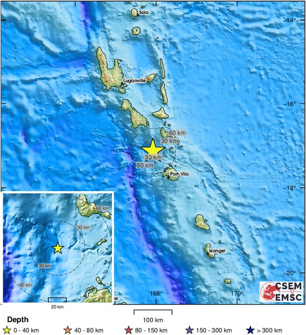

PVMBG reported that seismicity significantly increased at Ruang on 29 April and the signals indicated magma moving towards the surface. Earthquakes began to be felt at 0015 on 30 April. At 0115 the earthquakes intensified; residents in neighboring Tagulandang Island reportedly felt continuous shaking, heard loud roaring, and saw an ash plume rising about 2 km above the summit. Activity continued to escalate and at 0130 the Alert Level was raised to 4 (the highest level on a scale of 1-4). The public was warned to stay 7 km away from the active crater and residents on Tagulandang within 6 km were instructed to evacuate. A webcam photo from 0232 on 30 April showed lava being ejected above the summit; an eruptive event was recorded in seismic data at 0235. According to the Darwin VAAC ash plumes had risen to 15.2 km (50,000 ft) a.s.l. by 0300 and to 19.2 km (63,000 ft) a.s.l. by 0320, and by 0620 were expanding radially; the plumes may have risen to 23 km (75,400 ft) a.s.l. or more based on other expert analysis.
PVMBG noted that at 0835 dense gray-to-black ash plumes rose at least 5 km and drifted E and S. A webcam photo from 0827 showed multiple pyroclastic density currents descending the flanks. According to a characterization by BNPB the eruption ejected incandescent lava high above the summit and lightning was frequently seen in the plumes. Tephra fell over a more extensive area compared the 16-18 April eruption phase; gravel-sized tephra fell in Apengsala, about 8 km NNE from Ruang?s central vent, and outside of the exclusion zone. According to a news report residents felt shock waves from the explosions. At least three eruptive events were recorded during 1200-1800 that produced gray-and-black ash plumes at least as high as 1.5 km. The VAAC noted that by 1510 the high-level plume had detached from the summit and was drifting W and SW, and ash between 13.7-19.2 km (45,000-63,000 ft) a.s.l. continued to be identified drifting WNW at least through 0940 on 1 May. Ash plumes continued to be identified in satellite images, rising to 3 km (10,000 ft) a.s.l. and drifting N and SE at least through 1240 on 1 May.
According to a news report the eruption and the presence of ash and ashfall caused the closure of seven airports, scheduled to reopen on 1 May: the Sam Ratulangi International Airport (98 km SW in Manado, North Sulawesi), the Gorontalo Airport (371 km SW), the Siau/Sitaro Airport (40 km N), the Bolaang Mongondow Airport (215 km SW), the Tahuna/Naha Airport (150 km N), the Pohuwato Airport (445 SW), and the Pogogul Airport (460 km WSW). On 1 May about 123 residents were evacuated to Bitung City by boat. Ashfall was notable at the Sam Ratulangi International Airport with delays affecting about 7,000 passengers.
Sources: Andrew Tupper, Natural Hazards Consulting ,Antara News,Antara News,Antara News,Antara News,Antara News,Badan Nacional Penanggulangan Bencana (BNPB) ,Darwin Volcanic Ash Advisory Centre (VAAC),Pusat Vulkanologi dan Mitigasi Bencana Geologi (PVMBG, also known as CVGHM)